

There are 6 named storms in the Western Hemisphere
Read full article: There are 6 named storms in the Western HemisphereA NOAA satellite image of the six tropical systems in the Western Hemisphere. By late morning, there were six named storms moving in the Atlantic, over the United States or in the Eastern Pacific. Tropical Depression ImeldaImelda, once a tropical storm in the Gulf of Mexico, was flooding parts of the Houston area on Wednesday morning as a tropical depression. Tropical Storm JerryJerry, still hundreds of miles east of the Caribbean Sea's easternmost islands, could become a hurricane by Thursday night, the National Hurricane Center said. Tropical Storm KikoKiko, once a hurricane in the Pacific, could become a hurricane again by Friday or Saturday, the National Hurricane Center said.

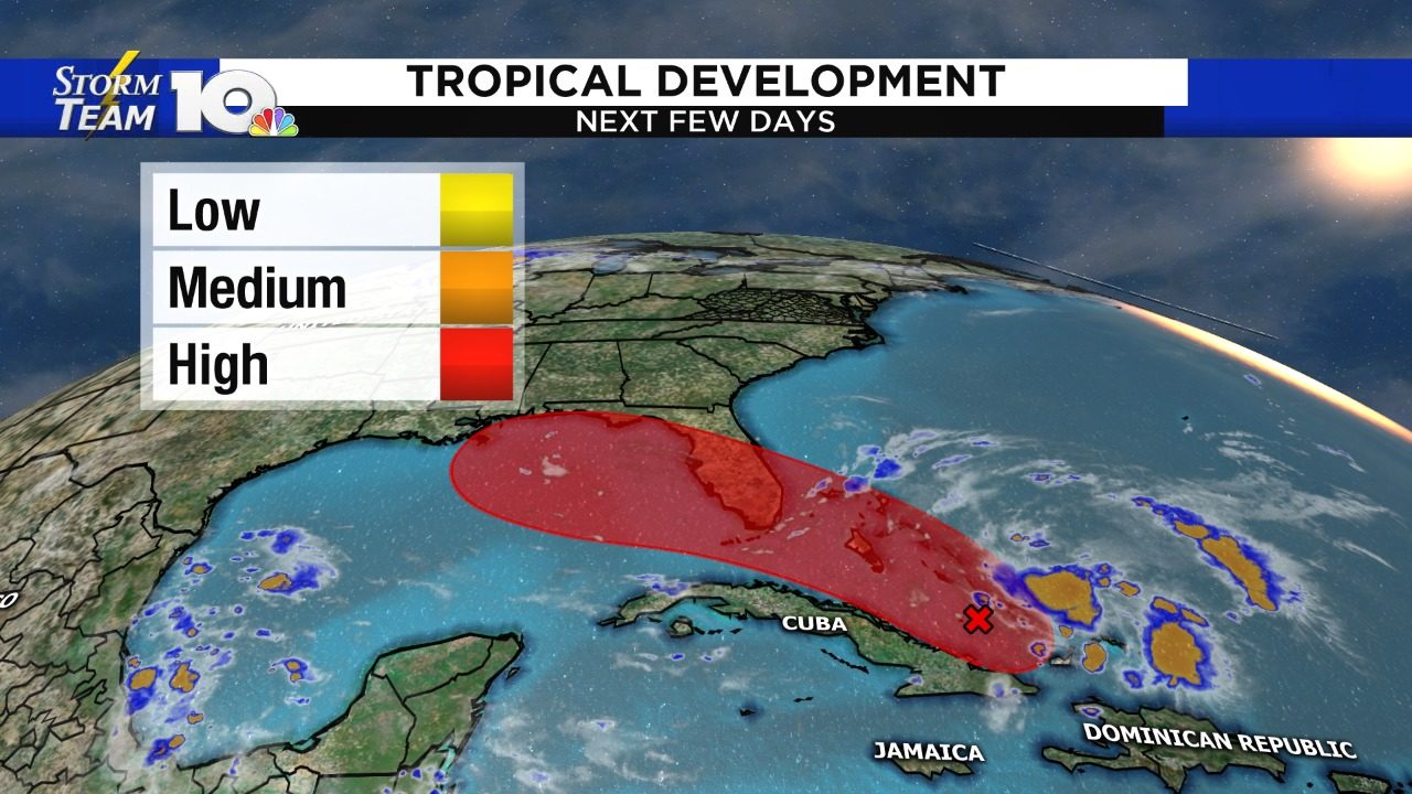
Active tropics with multiple named storms
Read full article: Active tropics with multiple named stormsAccording to the National Hurricane Center, Humberto is expected to pass to the north of Bermuda as a Category 3 Wednesday. Wednesday morning, Tropical Depression 10 became Tropical Storm Jerry. Tropical Depression Imelda will continue to bring very heavy rainfall to parts of Texas and Louisiana for the next 48 hours. The eastern Pacific Basin currently has three tropical storms which are Kiko, Mario and Lorena. According to the National Hurricane Center, each of the tropical storms in the Pacific will become hurricanes by the end of the work week.

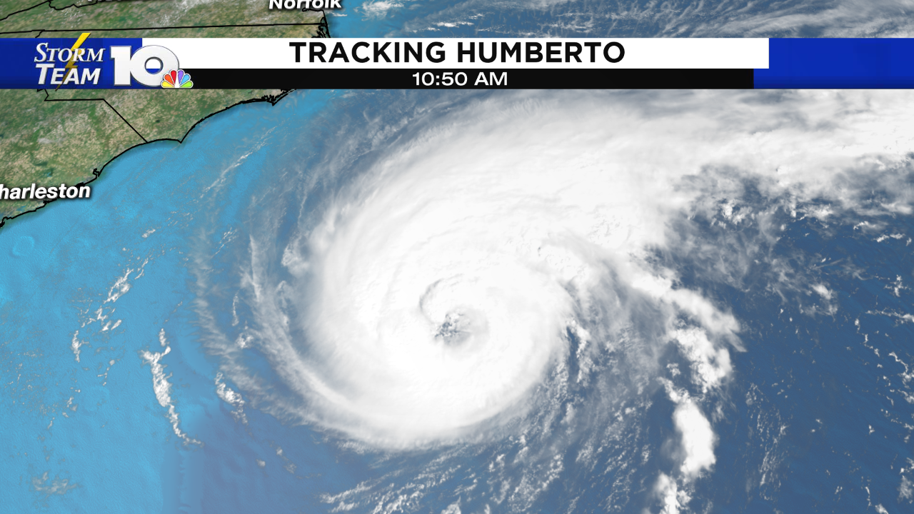
Category 3 Humberto may swipe Bermuda Wednesday
Read full article: Category 3 Humberto may swipe Bermuda WednesdayHumberto, a sprawling Category 3 storm, is packing sustained winds of 115 mph as it pushes east-northeast about 285 miles west of Bermuda, the National Hurricane Center said Wednesday at 5 a.m. Two to 4 inches of rain, dangerous waves along south-facing beaches and a storm surge of 1 to 3 feet also are expected, the hurricane center said. And Tropical Storm Jerry, still far east of the Leeward Islands, could strengthen into a hurricane by week's end. Humberto could strengthen as it passes Wednesday into Thursday morning less than 100 miles to the island's north, Jones and Garrett said. "Weather should begin to deteriorate in Bermuda later today," the hurricane center said early Wednesday.
Humberto a Category 2 storm; Tropical Depression 10 forms
Read full article: Humberto a Category 2 storm; Tropical Depression 10 formsROANOKE, Va. - In the weeks following Dorian, the tropics have remained active. Thankfully, no storm has directly impacted U.S. soil since that storm. Humberto is a Category 2 hurricane, as of Tuesday morning, and continues to move out to sea. Meanwhile, Tropical Depression 10 has developed over the open Atlantic and will move near/north of the Caribbean islands this weekend. It is forecast to become Tropical Storm Imelda either Tuesday night or Wednesday morning.

Humberto is now a hurricane, moves away from Bahamas
Read full article: Humberto is now a hurricane, moves away from BahamasFREEPORT, Bahamas - The Bahamas missed the brunt of Tropical Storm Humberto, which became a hurricane early Monday. Humberto is moving away from the Bahamas and was about 210 miles (335 km) northwest of Great Abaco Island and 170 miles (270 km) east of Cape Canaveral, Florida, according to the National Hurricane Center. The storm is forecast to continue moving away from the Bahamas and remain well offshore of Florida's east coast through Wednesday, the center said. Fears of a second stormThere was concern about what Humberto would bring to the Bahamas, where hundreds are still missing after the Category 5 Hurricane Dorian hit the Abaco Islands and Grand Bahama. The islands did get some rain, Van Dam said, but did not get Humberto's full impact.

Tropical storm Humberto gets closer
Read full article: Tropical storm Humberto gets closerA tropical depression is poised to hit the same northern Bahamian islands that Hurricane Dorian ravaged earlier this month -- and it may be a tropical storm when it does. (CNN) - Humberto is now a tropical storm barreling its way through the Atlantic and threatening the same northwestern Bahamas islands ravaged by Hurricane Dorian nearly two weeks ago. A tropical storm warning was in effect for the northwestern Bahamas, excluding Andros Island, the center said. "Since there is increasing confidence that the storm will remain well offshore of the coast of Florida, the tropical storm watch for that area has been discontinued," the center said. Swells generated by the tropical storm are expected to increase and affect the coasts of central Florida to South Carolina through early next week.

Storm in Caribbean forecast to become Humberto by Saturday morning
Read full article: Storm in Caribbean forecast to become Humberto by Saturday morningROANOKE, Va. - The National Hurricane Center has begun issuing advisories and forecasts for a storm that will likely become Humberto Saturday morning. Their forecast takes the storm through the Bahamas and then close to the East Coast through early next week as a tropical storm, before being ushered out to sea as a Category 1 hurricane. It's important to note, however, that there is room for change with this forecast. As you can see below, there's not a well-defined center to the storm. The reason why there's room for change is that the hurricane hunters are investigating the storm Friday.
TROPIC UPDATE: Next storm developing in the tropics
Read full article: TROPIC UPDATE: Next storm developing in the tropicsA storm currently near the Turks and Caicos has been given a high probability of becoming our next named storm, Humberto. It will take some time, as it's moving into an area of high wind shear. Wind shear refers to change in wind direction and speed, which tropical systems typically don't like. Where it goes is a very tricky aspect of the forecast, as there's no clear and defined center to the storm. A south Florida impact with a recurve north and west of here would mean a minor impact to our area.